Utah braces for extreme heat and elevated wildfire risk
Tap title to read story
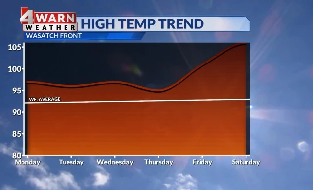
Salt Lake City: ABC4 meteorologists warned Utah residents Monday and Tuesday that a dangerous heat wave will build this week, with daytime highs in northern valleys reaching the mid-to-upper 90s and southern Utah, including St. George, Zion and Moab, climbing into the 100°–105° range or higher by the weekend.
The forecasts on Tuesday said isolated high-based thunderstorms and gusty southerly winds could produce dry lightning and gusts up to 60 mph, prompting the Storm Prediction Center to outline a level 1 marginal risk and the issuance of Red Flag Warnings for portions of central and southern Utah for Tuesday and Wednesday; agencies advised monitoring conditions.
Timeline
- 1. Monday: ABC4 reports mid-to-upper 90s across northern Utah and 100°–105° in southern valleys.
- 2. Monday: SPC issues a level 1 'Marginal' risk for northern Utah for isolated high-based storms.
- 3. Tuesday: Forecasts note continued dry thunderstorms, gusty winds, and single-digit humidities in southern Utah.
- 4. Tuesday: Red Flag Warnings issued for portions of central and southern Utah for Tuesday–Wednesday.
- 5. Friday–Weekend: Warming trend expected to produce the most extreme heat of the week.
Sources
JQJO Editorial Desk · Human reviewed · AI assisted. Report a correction.