Heat Dome Shifts; Monsoonal Moisture Brings Relief, Risks
Tap title to read story
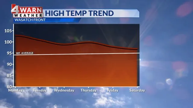
Salt Lake City — ABC4 meteorologists reported Monday that a weekend heat dome produced record high temperatures across Utah, and triple-digit heat persisted into Monday in many valleys and hotspots. As the heat dome shifted east, increased monsoonal moisture began streaming in from the southwest, bringing more cloud cover and the chance of isolated storms.
This week officials issued Extreme Heat Warnings for north and central valleys through early Tuesday, while power outages began as air-conditioning demand spiked on Sunday and Monday. By Tuesday warnings were allowed to expire in some areas, but forecasters emphasized ongoing heat-related health risks, localized flash-flood potential in southern slot canyons, and continued monitoring.
More context
Timeline
- 1. Sunday: Record-breaking temperatures observed across Utah under a strong heat dome.
- 2. Monday morning: Extreme Heat Warnings active for most north and central valleys.
- 3. Monday afternoon-evening: Monsoonal moisture begins streaming into southern and central Utah, producing clouds and isolated storms.
- 4. Monday evening: Increased electricity demand led to reported power outages in parts of the state.
- 5. Tuesday: Warnings expire in some areas; showers and thunderstorms increase with localized flash-flood risk in southern slot canyons.
Why it matters
The shifting heat dome affects your safety and comfort. Extreme heat can pose health risks, especially for the elderly and young children. Power outages may disrupt your daily routine. If you're in southern Utah, be aware of flash-flood potential.
Sources
JQJO Editorial Desk · Human reviewed · AI assisted. Report a correction.