Record Gulf Heat Triggers Extreme Humidity and Severe Storm Alerts Across Florida
Tap title to read story
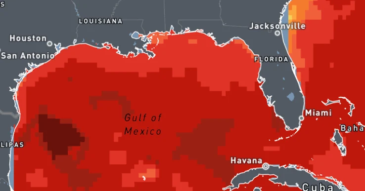
Record-breaking sea surface temperatures in the Gulf of Mexico have surged between 88 and 90 degrees Fahrenheit for late August, registering one to three degrees above average. Climate Central scientists attribute these anomalies to human-induced climate change, which makes ocean thermal spikes exponentially more frequent. Persistent onshore winds are channeling this unprecedented moisture and energy directly into Florida and adjacent coastal communities, creating severe heat stress and elevated heat indices. Simultaneously, the supercharged lower atmosphere is fueling scattered-to-severe thunderstorm alerts across the region. Local meteorological stations and emergency management authorities have issued warnings for torrential downpours and hazardous heat risks as unstable atmospheric conditions persist into September. Public safety officials advise residents to monitor official weather advisories, limit outdoor exertion during peak hours, and prepare for sudden localized flooding caused by intense precipitation.
Timeline
- On August 1, 2026, Gulf sea surface temperatures began rising steadily above historical averages.
- On August 10, 2026, climate researchers noted abnormal basin-wide thermal energy accumulation trends.
- On August 20, 2026, meteorological instruments recorded sustained surface temperatures approaching eighty-eight degrees.
- On August 25, 2026, persistent onshore wind patterns intensified regional humidity and heat stress.
- On August 28, 2026, Climate Central confirmed ocean readings reached record late-August levels.
- On August 29, 2026, National Weather Service stations issued severe thunderstorm and heat alerts.
- On August 30, 2026, emergency management teams deployed localized public safety advisory notifications.
- On August 31, 2026, extreme humidity and heavy downpours impacted coastal Florida communities.
- On September 1, 2026, unstable weather patterns continued driving severe storm risks across Florida.
- On September 5, 2026, meteorologists anticipate atmospheric conditions will gradually normalize across the region.
- On September 15 2026 By mid-September 2026, ocean temperatures are expected to cool from peak levels.
- On October 1 2026 By October 2026, seasonal weather transitions will reduce severe tropical storm risks.
Sources
JQJO Editorial Desk · Human reviewed · AI assisted. Report a correction.