Big Sur Timber Fire Surges Near 5,000 Acres As Evacuations Expand In California
PUBLISHED Aug 15, 2026, 10:34 PM ET
Read, Watch or Listen
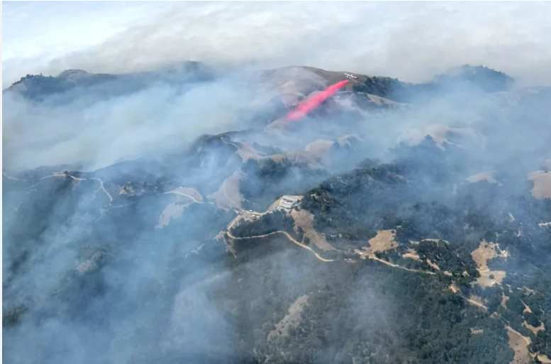
The Timber Fire burning along California's rugged Big Sur coastline has grown to 4,869 acres in Monterey County, with containment increasing to 15 percent as of Saturday afternoon. The wildfire, located within the Los Padres National Forest, expanded by roughly 7 percent over a 24-hour period despite heavy deployment of aerial resources and ground crews. CAL FIRE reported that more than 1,800 firefighters are currently assigned to the incident. Air tankers and heavy helicopters dropped fire retardant and water throughout the day, reinforcing and connecting containment lines across steep, inaccessible terrain. Bulldozer lines completed on the north side of the fire helped slow its progression toward the Big Sur River, while night-shift crews worked to secure perimeters near Castro Canyon and Partington Road. Over 500 structures remain threatened by the advancing flames, particularly near Partington Ridge Road and Castro Canyon, where active hotspots were detected above residential properties. Ground crews maintained structure defense operations, cutting handlines behind homes east of state Highway 1. As of Saturday, no injuries or structural destructions have been officially reported. Evacuation orders remain in effect for zones stretching from Partington Creek to Pheneger Creek, impacting roughly 640 residents. An additional 350 individuals remain under evacuation warnings. Monterey County Sheriff's Department and CAL FIRE Incident Management Team 1 continue to coordinate emergency response operations in the area. A 10-mile stretch of state Highway 1 remains closed to the public between two miles north of Julia Pfeiffer Burns State Park and the Big Sur Bakery to ensure emergency vehicle access and public safety. The highway closure has disrupted travel along the scenic coastal corridor as firefighting operations continue. The fire originally ignited on August 8 near Timber Top Trail. While heavy marine layers brought high humidity and cooler overnight temperatures, dry conditions and high winds at higher elevations above 1,000 feet continue to fuel active fire behavior. The cause of the Timber Fire remains under investigation by federal and state authorities.
By Yusra M. | JQJO News
Timeline of Events
- On August 9, 2026, fire broke out in the forest.
- On August 10, 2026, flames doubled across steep rugged terrain.
- On August 11, 2026, mandatory evacuations targeted popular tourist destinations.
- On August 12, 2026, aircraft dropped water and fire retardant lines.
- On August 13, 2026, crews expanded bulldozer lines protecting structures.
- On August 14, 2026, Highway 1 remained closed for access.
- On August 15, 2026, containment reached fifteen percent near ridges.
- On August 16, 2026, eighteen hundred personnel battled active spots.
- Firefighters will reinforce perimeter lines against dry winds next week.
- Authorities expect full containment progress before autumn seasonal rains arrive.
- Officials will lift evacuation orders once structural threats subside entirely.
News Intelligence
- Immediate US impact: Evacuations and Highway 1 closures disrupt coastal travel and communities.
- Possible long-term US impact: Heightened regional wildfire resilience planning across California coastal park ecosystems.
- Most affected groups: Big Sur residents, local tourism businesses, and emergency response personnel.
- Reader Priorities: Monitor official Cal Fire updates and local emergency evacuation orders.
Coverage of Story:
From Left
Famed tourist destinations evacuated as wildfire threatens California's Big Sur
The Guardian




Comments