Hidden Forest Fire Triggers Immediate Evacuations Near Bend
PUBLISHED Aug 12, 2026, 12:02 AM ET
Read, Watch or Listen
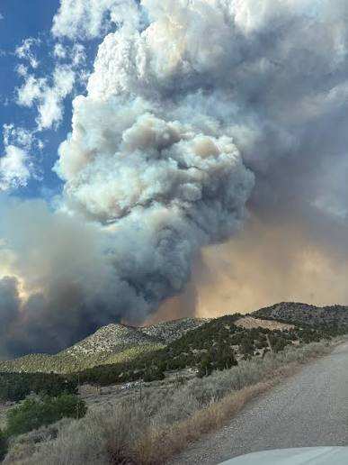
The Deschutes County Sheriff's Office triggered widespread public alarm after issuing a county-wide wireless emergency alert for the fast-moving Hidden Forest Fire burning southeast of Bend, Oregon. Sparking near Forest Service Road 18 and the Arnold Ice Cave area, the blaze prompted Level 3 "Go Now" evacuation orders. Approximately 200,000 mobile phones across the county buzzed with the emergency notice, causing sudden confusion in public spaces like the Redmond Airport and downtown Bend as recipients far outside the immediate danger zone received the broadcast. Officials defended the broad notification as a necessary precaution to reach recreational visitors who might be stranded in remote forested areas without local subscription alerts. The wildfire quickly charred 297 acres of sagebrush and juniper on Deschutes National Forest land before ground crews and aerial assets established solid containment lines. Authorities later raised containment to 80 percent as firefighters transitioned into intensive mop-up operations to secure perimeter hot spots.
By Nimra K. | JQJO News
Timeline of Events
- On August 7, 2026, the Hidden Forest Fire sparked southeast of Bend, Oregon.
- On August 7, 2026, Deschutes County issued Level 3 evacuation orders for recreation areas.
- On August 8, 2026, the fire expanded rapidly to cover approximately 297 total acres.
- On August 9, 2026, infrared drone flights mapped interior heat and remaining smoldering pockets.
- On August 10, 2026, fire crews successfully increased containment perimeter boundaries to 80 percent.
- On August 11, 2026, officials explained the rare countywide mobile emergency alert mass broadcast.
- On August 12, 2026, mop-up operations continued with ground personnel monitoring remaining active hot spots.
- On August 13, 2026, authorities anticipate scaling down active personnel as perimeter security holds firm.
- On August 15, 2026, forest service managers expect to lift remaining localized recreation area closures.
- On September 1, 2026, seasonal drying trends will likely maintain heightened wildfire watch protocols.
News Intelligence
- Mass emergency mobile alerts spark widespread public panic across communities.
- Heightened wildfire risks demand advanced automated public warning infrastructure nationwide.
- Residents, campers, tourists, and local emergency management agencies in Oregon.
- Monitor official county emergency channels and local sheriff department social updates.
Coverage of Story:
From Left
Wildfire near popular Oregon recreation area burns 297 acres, prompting heavy air tanker response
CNNFrom Center
Decision to send mass fire evacuation alert was rare for Deschutes County
The Bulletin Central Oregon Fire Information Your Oregon News Hindustan Times Woodland Fire Fighter The Bulletin Central Oregon Fire Information Central Oregon Interagency Dispatch Central Oregon Fire Updates Woodland Fire Fighter Woodland Fire Fighter Tracker The Source Weekly Hindustan Times KTVZ Local News Channel 21 OPB (Oregon Public Broadcasting) The Oregonian Associated Press Reuters KATU ABC 2 KGW News KOIN 6 News NBC NewsFrom Right
Oregon wildfire near Bend triggers urgent evacuations and massive cell phone alert test of emergency system
Fox News






Comments