Utah forecasts: cooler start, critical fire danger returns
Tap title to read story
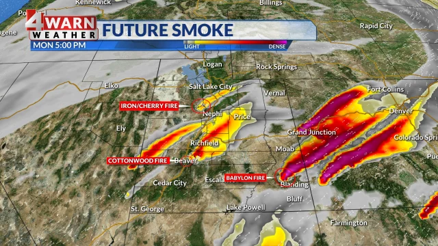
SALT LAKE CITY. This week Utah experienced below-average temperatures early Monday and Tuesday, with daytime highs ranging from the upper 60s to low 90s depending on region, and persistent smoke from western wildfires including the Iron, Cherry and Cottonwood Fires. Local forecasts on Monday and Tuesday noted cooler northwest flow, isolated mountain shower chances, and lingering smoke downwind in the valley.
By Wednesday the forecast calls for a wind shift to southerly flow, bringing drier air, gusts up to 35 mph and relative humidities near 8–12 percent; officials announced Red Flag Warnings for much of eastern Utah from 12pm to 9pm, and warned that critical fire danger will build from south to north midweek, sustaining smoke and air-quality impacts.
Timeline
- 1. Monday: Northwest flow yields below-average temperatures and lingering wildfire smoke.
- 2. Late Monday afternoon: Patchy smoke expected across Utah Valley downwind of Iron and Cherry Fires.
- 3. Tuesday: Continued cooler northwest flow with isolated mountain shower chances; elevated fire danger persists.
- 4. Wednesday morning: Winds shift from north to south, introducing drier air and stronger gusts.
- 5. Wednesday afternoon–evening: Red Flag Warnings in eastern Utah with critical fire danger and gusts up to 35 mph.
Sources
JQJO Editorial Desk · Human reviewed · AI assisted. Report a correction.