Warm surge precedes multi-day storm and flood risks
Read, Watch or Listen
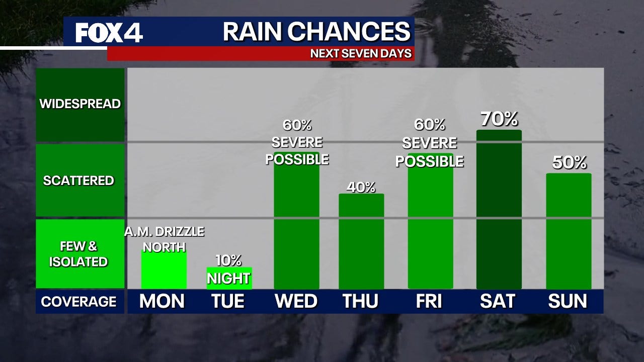
United States — Multiple regional weather services report that warm, humid air will precede rounds of rain and thunderstorms this week, escalating to severe hazards midweek. Tuesday will produce widespread warmth and isolated precipitation in several areas, with fronts and lows triggering heavier showers Wednesday into Thursday. The Storm Prediction Center assigned marginal to slight severe risk zones for portions of Texas and Kentucky, while local forecasts warned of hail, damaging winds, localized flooding and isolated tornadoes. Rivers and low-lying areas face flash-flood potential. Residents should monitor forecasts for changing timing and impacts. Based on 6 articles reviewed and supporting research.
Prepared by Olivia Bennett and reviewed by editorial team.
Timeline of Events
- Warm, moist air moves north, producing above-normal temperatures regionally.
- Tuesday brings widespread warmth and isolated precipitation ahead of frontal systems.
- A cold front and associated systems arrive midweek, prompting widespread rain and storms.
- Storm Prediction Center issues Marginal to Slight risk designations for some areas.
- Additional systems and a stronger front maintain storm and flood potential through the weekend.
Why This Matters to You
Your safety and property are at stake. The warm surge can lead to heavy rain, hail, and damaging winds. Low-lying areas may face flash floods. If you're in Texas or Kentucky, you're in the risk zone. Check your local weather forecast regularly.
The Bottom Line
This week's weather isn't just about staying dry. It's about preparing for potential hazards. Secure your property, and have a safety plan in place. Worth forwarding if you know someone in the storm's path.
- Articles Published:
- 8
- Right Leaning:
- 0
- Left Leaning:
- 0
- Neutral:
- 8
- Distribution:
- Left 0%, Center 100%, Right 0%
Local meteorologists, emergency management agencies, and residents who heed warnings benefit from advanced notice and preparation time to reduce harm and manage resources.
Communities in low-lying, flood-prone, or wind-exposed areas, outdoor event organizers, and vulnerable motorists may suffer property damage, travel disruption, and safety risks from heavy rain and severe storms.
Coverage of Story:
From Left
No left-leaning sources found for this story.
From Center
Warm surge precedes multi-day storm and flood risks
FOX 4 News Dallas-Fort Worth WEWS WISH-TV | Indianapolis News | Indiana Weather | Indiana Traffic https://www.wkyt.com WKEF FOX 4 News Dallas-Fort Worth FOX 4 News Dallas-Fort Worth FOX 4 News Dallas-Fort WorthFrom Right
No right-leaning sources found for this story.


Comments