Calor intenso y riesgo de incendios en Georgia antes de la llegada de un frente frío
Read, Watch or Listen
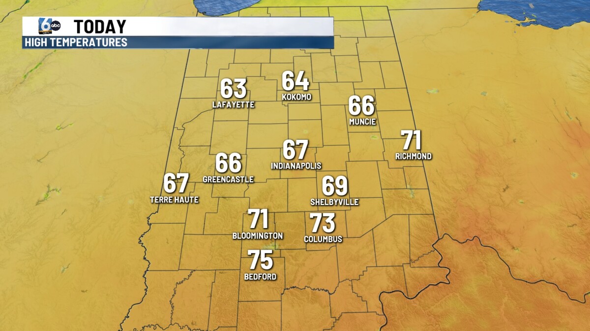
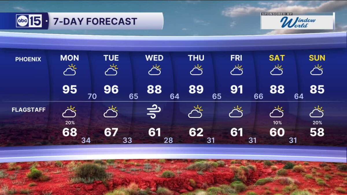
ATLANTA, Ga. — A strong ridge of high pressure extending from the Gulf will keep Atlanta and much of Georgia very warm and dry today, with mostly clear skies, breezy southwest winds and temperatures climbing from the 60s this morning into the upper 80s to low 90s this afternoon. The heat could challenge daily records in some locations. Low humidity, gusty winds and dry vegetation are the main concerns for anyone with outdoor plans. Late this evening a cold front moving through the Tennessee Valley into northwest Georgia is expected to bring an organized line of showers and possibly an isolated thunderstorm or two, but rainfall amounts are likely to be limited and the line should weaken toward sunrise. After the front passes, a much cooler and drier air mass will settle over the region, producing a dramatic change from Saturday’s heat. Sunday afternoon will be breezy with northwest winds around 10–15 mph and gusts to 25 mph, and very low relative humidity will create fire-weather concerns; a Red Flag Warning may be needed in some areas. Sunday night temperatures will fall into the low to mid 40s inland. High pressure will build early next week, keeping conditions dry and temperate with continued fire danger and limited chances for beneficial rainfall through the next seven days as temperatures trend back above normal by mid to late week.
Prepared by Emily Rhodes and reviewed by editorial team.
Timeline of Events
- Alta presión y la dorsal del Golfo traen calidez récord y condiciones secas en el sureste (sábado).
- Las brisas del suroeste y la baja humedad persisten hasta el sábado por la tarde con peligro elevado de incendio.
- Un frente frío avanza tarde el sábado por la noche hasta el domingo temprano, produciendo chubascos organizados y tormentas aisladas.
- La lluvia sale el domingo por la mañana; las temperaturas caen drásticamente con vientos frescos del norte/noreste el domingo y lunes.
- Aire más fresco y seco y vientos costeros racheados continúan el lunes y martes antes de que el calentamiento gradual se reanude a mitad de semana.
Why This Matters to You
Este cambio de tiempo afecta tus planes de fin de semana. Si estás al aire libre, ten en cuenta el riesgo de incendio debido a la baja humedad y los vientos racheados. La repentina caída de temperatura podría afectar tu salud, especialmente si eres sensible al frío. Verifica que tu sistema de calefacción funcione correctamente.
The Bottom Line
El clima está cambiando rápidamente de un calor récord a un frente frío. Prepárese para chubascos, posibles tormentas y una caída significativa de la temperatura. Esté atento a las advertencias de bandera roja. Vale la pena reenviar si conoce a alguien que planea actividades al aire libre este fin de semana.
- Articles Published:
- 4
- Right Leaning:
- 0
- Left Leaning:
- 0
- Neutral:
- 4
- Distribution:
- Left 0%, Center 100%, Right 0%
Los gerentes de emergencia, las autoridades de puertos costeros y las empresas sensibles al clima se beneficiaron de pronósticos y tiempos anticipados que permiten la preparación para vientos racheados, chubascos localizados y condiciones más frías.
Los organizadores de eventos al aire libre, los navegantes recreativos y las comunidades afectadas por la sequía sufrieron un continuo riesgo de incendios y solo lluvias limitadas, y es poco probable que algunas áreas vean un alivio significativo de la sequía.
Coverage of Story:
From Left
No left-leaning sources found for this story.
From Center
Calor intenso y riesgo de incendios en Georgia antes de la llegada de un frente frío
https://www.atlantanewsfirst.com https://www.wbtv.com https://www.wbrc.com WPTVFrom Right
No right-leaning sources found for this story.


Comments