Rapid warmup, then frontal system brings rain, wind, snow
Read, Watch or Listen
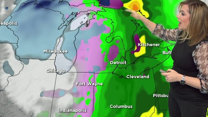
Detroit and U.S. regions will face a rapid weather shift Thursday into Friday as a Pacific frontal system brings rain, strong winds, and a sharp temperature drop. Meteorologists reported daytime highs in the 30s to 50s Wednesday and upper 40s to low 50s Thursday, followed by a 20-degree overnight plunge. Rain, possible freezing rain, and half-inch rainfall totals are expected before precipitation changes to snow, creating black ice and travel hazards; wind gusts of 45–75 mph prompted high wind warnings and winter storm alerts in mountainous areas. Some school districts may close Friday. Based on 11 articles reviewed and research.
Prepared by Emily Rhodes and reviewed by editorial team.
Timeline of Events
- Early-week warmup raised temperatures and melted existing snowpack across regions.
- Wednesday–Thursday: clouds increase and rain begins in many areas with measured rainfall expectations.
- Late Thursday: Pacific cold front advances east, producing strong winds and rapid temperature decline.
- Overnight Thursday–Friday: rain changes to freezing rain and snow; black ice forms, worsening road conditions.
- Friday into weekend: NWS warnings and advisories remain active for mountain snow, wind, and hazardous travel.
- Articles Published:
- 13
- Right Leaning:
- 0
- Left Leaning:
- 0
- Neutral:
- 13
- Distribution:
- Left 0%, Center 100%, Right 0%
Local road maintenance, utility repair crews, snow removal contractors, and retailers selling winter supplies will see increased demand and revenue as communities respond to wind, rain, freezing conditions, and mountain snow this week.
Commuters, school districts considering closures, vulnerable residents, and mountain communities face hazardous travel, power outages, property damage, and disruption to holiday plans due to strong winds, flash freezes, and heavy snow.
Coverage of Story:
From Left
No left-leaning sources found for this story.
From Center
Rapid warmup, then frontal system brings rain, wind, snow
WDIV https://www.wsaw.com KPAX mlive https://www.wdtv.com Cleveland KPAX https://www.cleveland19.com KXLF KPAX WDIV KPAX KPAXFrom Right
No right-leaning sources found for this story.


Comments